Storm expected to bring rain, winds to Tri-City area
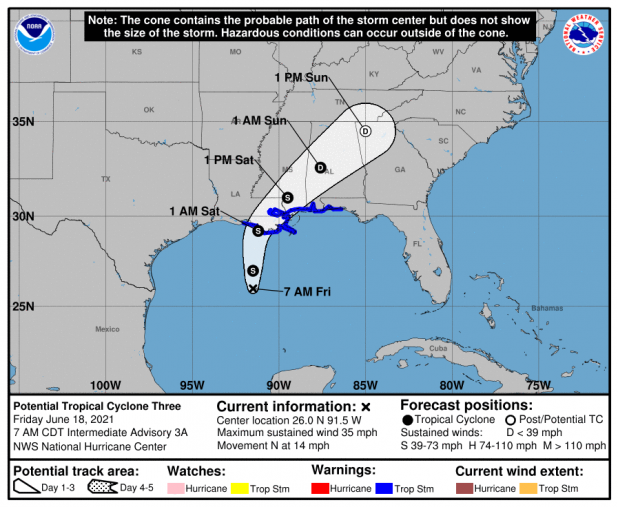
Potential Tropical Cyclone 3 in the Gulf of Mexico is expected to become a tropical storm Friday, and Morgan City is included in a tropical storm warning, the National Hurricane Center reported Friday.
The warning is from south of Lafayette into the Florida panhandle according to the National Hurricane Center’s website.
The system is expected to bring with it rain, winds and possible tornadoes.
The hurricane center reported that the disturbance developed some more organization overnight. As of 4 a.m. Friday morning, it has maximum sustained winds of 35 mph and is moving 14 mph north.
The storm will bring with it a lot of rainfall, “considerable flash, urban and small stream flooding” that is anticipated to begin Friday and remain for the weekend in the central Gulf Coast, the hurricane center reported.
Those areas near and much further to the east of the storm are expected to experience tropical storm conditions, beginning Friday. That area is expected from Intracoastal City all the way into Florida.
The storm is expected to slowly gain strength before landfall. After it hits land, the system is expected to produce a lot of rain and tropical-storm force winds, the hurricane center reported.
In anticipation of the storm, Gov. John Bel Edwards has issued a state of emergency.
“According to the National Weather Service (NWS), rainfall will be the biggest threat,” Edwards said in a news release. “In addition to heavy rains, there is also a threat of coastal flooding, tropical storm force winds and isolated tornadoes. The Governor’s Office of Homeland Security and Emergency Preparedness has activated its Crisis Action Team and stands ready to support our local partners with any emergency resources needed beyond parish capabilities. It is important to stay weather aware as these storms approach the coast. Go to GetAGamePlan.org to help finalize your emergency plans. Start with getting a COVID-19 vaccination for you and your family.”
Motorists also should refrain from traversing flooded roadways or driving in areas marked off by barricades. For road updates, visit www.511la.org.
Locally, out of caution, St. Martin Parish President Chester Cedars announced on the parish’s Facebook page that sandbagging sites have opened in Lower St. Martin Parish at Stephensville Park and across from the Belle River Fire Station. Locals will have to fill their own sandbags and are asked to take no more than 25 sandbags per vehicle.
St. Martin Parish government said in its post that it doesn’t anticipate the system having major impacts on the parish.
Those who need assistance with sandbagging due to a disability should call the parish’s Office of Emergency Preparedness at 337-394-2808.
Also locally, the town of Berwick has sand, sandbags and shovels available under the elevated U.S. 90 bridge at Town Hall for residents to come fill bags.
St. Mary Parish government has sand and sand bags in the Tri-City area at the public works facility at 2717 La. 182 East in Bayou Vista and under the La. 182 bridge in Amelia.
In Patterson, the city has sand and sand bags at the city’s Public Works Plant (water tower) on Taft Street for the city’s residents in vulnerable areas. Residents will need to bring their own shovel.