
UPDATED 1:15 P.M.: Hurricane, storm surge warning for Morgan City; 4 inches of rain expected
NATIONAL HURRICANE CENTER
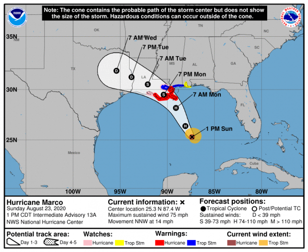
HURRICANE MARCO
BULLETIN
Hurricane Marco Intermediate Advisory Number 13A
NWS National Hurricane Center Miami FL AL142020
100 PM CDT Sun Aug 23 2020
...HURRICANE MARCO CROSSING THE CENTRAL GULF...
...LIFE-THREATENING STORM SURGE AND HURRICANE-FORCE WINDS EXPECTED
ALONG PORTIONS OF THE U.S. GULF COAST MONDAY...
SUMMARY OF 100 PM CDT...1800 UTC...INFORMATION
----------------------------------------------
LOCATION...25.3N 87.4W
ABOUT 280 MI...450 KM SSE OF THE MOUTH OF THE MISSISSIPPI RIVER
ABOUT 440 MI...710 KM SE OF LAFAYETTE LOUISIANA
MAXIMUM SUSTAINED WINDS...75 MPH...120 KM/H
PRESENT MOVEMENT...NNW OR 340 DEGREES AT 14 MPH...22 KM/H
MINIMUM CENTRAL PRESSURE...992 MB...29.29 INCHES
WATCHES AND WARNINGS
--------------------
CHANGES WITH THIS ADVISORY:
None.
SUMMARY OF WATCHES AND WARNINGS IN EFFECT:
A Storm Surge Warning is in effect for....
* Morgan City Louisiana to Ocean Springs Mississippi
* Lake Borgne
A Hurricane Warning is in effect for...
* Morgan City Louisiana to the Mouth of the Pearl River
A Storm Surge Watch is in effect for...
* Sabine Pass to Morgan City Louisiana
* Ocean Springs Mississippi to the Mississippi/Alabama border
* Lake Pontchartrain and Lake Maurepas
A Hurricane Watch is in effect for...
* Intracoastal City Louisiana to west of Morgan City
* Lake Pontchartrain, Lake Maurepas, and Metropolitan New Orleans
A Tropical Storm Warning is in effect for...
* Mouth of the Pearl River to the Mississippi/Alabama border
* Lake Pontchartrain, Lake Maurepas, and Metropolitan New Orleans
A Tropical Storm Watch is in effect for...
* Mississippi/Alabama border to the Alabama/Florida border
A Storm Surge Warning means there is a danger of life-threatening
inundation, from rising water moving inland from the coastline,
during the next 36 hours in the indicated locations. For a
depiction of areas at risk, please see the National Weather
Service Storm Surge Watch/Warning Graphic, available at
hurricanes.gov. This is a life-threatening situation. Persons
located within these areas should take all necessary actions to
protect life and property from rising water and the potential for
other dangerous conditions. Promptly follow evacuation and other
instructions from local officials.
A Hurricane Warning means that hurricane conditions are expected
somewhere within the warning area. A warning is typically issued
36 hours before the anticipated first occurrence of
tropical-storm-force winds, conditions that make outside
preparations difficult or dangerous. Preparations to protect life
and property should be rushed to completion.
A Storm Surge Watch means there is a possibility of life-
threatening inundation, from rising water moving inland from the
coastline, in the indicated locations during the next 48 hours.
For a depiction of areas at risk, please see the National Weather
Service Storm Surge Watch/Warning Graphic, available at
hurricanes.gov.
A Hurricane Watch means that hurricane conditions are possible
within the watch area.
A Tropical Storm Warning means that tropical storm conditions are
expected somewhere within the warning area within 36 hours.
A Tropical Storm Watch means that tropical storm conditions are
possible within the watch area, generally within 48 hours.
For storm information specific to your area in the United States,
including possible inland watches and warnings, please monitor
products issued by your local National Weather Service forecast
office. For storm information specific to your area outside of the
United States, please monitor products issued by your national
meteorological service.
DISCUSSION AND OUTLOOK
----------------------
At 100 PM CDT (1800 UTC), the center of Hurricane Marco was located
near latitude 25.3 North, longitude 87.4 West. Marco is moving
toward the north-northwest near 14 mph (22 km/h), and this motion is
expected to continue through tonight, followed by a turn toward the
northwest by Monday. On the forecast track, Marco will cross the
central Gulf of Mexico today and will approach southeastern
Louisiana on Monday. A gradual turn toward the west-northwest with a
decrease in forward speed is expected after Marco moves inland.
Maximum sustained winds are near 75 mph (120 km/h) with higher
gusts. Marco is expected to be a hurricane when it approaches the
northern Gulf Coast on Monday. Rapid weakening is expected after
Marco moves inland.
Hurricane-force winds extend outward up to 20 miles (30 km) from
the center and tropical-storm-force winds extend outward up to 100
miles (160 km) from the center.
The estimated minimum central pressure is 992 mb (29.29 inches).
HAZARDS AFFECTING LAND
----------------------
STORM SURGE: The combination of a dangerous storm surge and the
tide will cause normally dry areas near the coast to be flooded by
rising waters moving inland from the shoreline. The water could
reach the following heights above ground somewhere in the indicated
areas if the peak surge occurs at the time of high tide...
Morgan City LA to Ocean Springs MS including Lake Borgne...4-6 ft
Sabine Pass to Morgan City LA...2-4 ft
Ocean Springs MS to the MS/AL Border...2-4 ft
Lake Pontchartrain and Lake Maurepas...2-4 ft
MS/AL Border to AL/FL Border including Mobile Bay...1-3 ft
The deepest water will occur along the immediate coast in areas of
onshore winds, where the surge will be accompanied by large and
dangerous waves. Surge-related flooding depends on the relative
timing of the surge and the tidal cycle, and can vary greatly over
short distances. For information specific to your area, please see
products issued by your local National Weather Service forecast
office.
WIND: Hurricane conditions are expected within the hurricane
warning area by midday Monday, with tropical storm conditions
possible by early Monday. Tropical storm conditions are possible
within the tropical storm watch area on Monday, and hurricane
conditions are possible within the hurricane watch areas late
Monday.
RAINFALL: Marco is expected to produce rainfall accumulations of 2
to 4 inches with isolated maximum amounts of 6 inches across the
Central U.S. Gulf coast through Tuesday.
This rainfall may result in isolated areas of flash and urban
flooding along the Central U.S. Gulf Coast.
SURF: Swells generated by Marco are likely to affect portions of
the northern Gulf Coast later today. These swells are likely to
cause life-threatening surf and rip current conditions. Please
consult products from your local weather office.
TORNADOES: An isolated tornado will be possible early Monday
morning near the southeast Louisiana coast.
NEXT ADVISORY
-------------
Next complete advisory at 400 PM CDT.
$$
Forecaster Latto
TROPICAL STORM LAURA
BULLETIN
Tropical Storm Laura Intermediate Advisory Number 15A
NWS National Hurricane Center Miami FL AL132020
200 PM EDT Sun Aug 23 2020
...LAURA HEADING TOWARD EASTERN CUBA...
...HEAVY RAINFALL AND LIFE-THREATENING FLASH FLOODING CONTINUES
OVER PORTIONS OF THE DOMINICAN REPUBLIC AND HAITI...
SUMMARY OF 200 PM EDT...1800 UTC...INFORMATION
----------------------------------------------
LOCATION...19.4N 74.3W
ABOUT 55 MI...90 KM S OF THE EASTERN TIP OF CUBA
ABOUT 80 MI...130 KM SE OF GUANTANAMO CUBA
MAXIMUM SUSTAINED WINDS...50 MPH...85 KM/H
PRESENT MOVEMENT...WNW OR 285 DEGREES AT 21 MPH...33 KM/H
MINIMUM CENTRAL PRESSURE...1004 MB...29.65 INCHES
WATCHES AND WARNINGS
--------------------
CHANGES WITH THIS ADVISORY:
The government of the Dominican Republic has discontinued the
Tropical Storm Warning along the south coast of the Dominican
Republic and has discontinued the warning along the north coast of
the Dominican Republic east of Samana.
SUMMARY OF WATCHES AND WARNINGS IN EFFECT:
A Tropical Storm Warning is in effect for...
* The northern coast of the Dominican Republic from Samana to
the border with Haiti
* Entire coast of the Haiti
* The southeastern Bahamas and the Turks and Caicos Islands
* Cuban provinces of Camaguey, Las Tunas, Holguin, Guantanamo,
Santiago de Cuba, Granma, Ciego De Avila, Sancti Spiritus, Villa
Clara, Cienfuegos, Matanzas, Mayabeque, La Habana, Artemisa, Pinar
del Rio, and the Isle of Youth
A Tropical Storm Watch is in effect for...
* The central Bahamas
* Andros Island
* Florida Keys from Ocean Reef to Key West and the Dry Tortugas
* Florida Bay
The Tropical Storm Warning means that tropical storm conditions are
expected somewhere within the warning area, in this case within the
next 12 to 24 hours.
A Tropical Storm Watch means that tropical storm conditions are
possible within the watch area, in this case within the next 24
hours.
For storm information specific to your area in the United
States, including possible inland watches and warnings, please
monitor products issued by your local National Weather Service
forecast office. For storm information specific to your area
outside of the United States, please monitor products issued by
your national meteorological service.
DISCUSSION AND OUTLOOK
----------------------
At 200 PM EDT (1800 UTC), the center of Tropical Storm Laura was
located near latitude 19.4 North, longitude 74.3 West. Laura is
moving toward the west-northwest near 21 mph (33 km/h), and this
general motion with some decrease in forward speed is expected over
the next couple of days. A turn toward the northwest is foreast on
Wednesday. On the forecast track, the center of Laura will move
near or over Cuba tonight and Monday, and move over the southeastern
Gulf of Mexico Monday night and Tuesday. Laura is expected to move
over the central and northwestern Gulf of Mexico Tuesday night and
Wednesday.
Maximum sustained winds are near 50 mph (85 km/h) with higher
gusts. Little change in strength is forecast while Laura moves near
Cuba. However, strengthening is forecast after the storm moves over
the Gulf of Mexico, and Laura is forecast to become a hurricane late
Tuesday or Tuesday night.
Tropical-storm-force winds extend outward up to 140 miles (220 km)
from the center.
The estimated minimum central pressure is 1004 mb (29.65 inches).
HAZARDS AFFECTING LAND
----------------------
RAINFALL: Laura is expected to produce the following rainfall
accumulations through Tuesday:
Dominican Republic, Haiti and Cuba: 4 to 8 inches, with maximum
amounts of 12 inches.
Jamaica: 2 to 4 inches, with maximum amounts of 6 inches.
This heavy rainfall could lead to life-threatening flash and urban
flooding, and the potential for mudslides across the Greater
Antilles.
Florida Keys, Turks and Caicos and southeast Bahamas: 1 to 3 inches.
WIND: Tropical storm conditions are expected within portions of
the warning area in the Dominican Republic and Haiti through
this evening. Tropical storm conditions are expected within
portions of the warning area in Cuba later today through Monday.
Tropical storm conditions are possible within portions of the watch
area tonight through Monday evening.
SURF: Swells generated by Laura are affecting portions of Puerto
Rico, Hispaniola, eastern Cuba, the southeastern Bahamas and the
Turks and Caicos Islands. These swells are expected to spread
across central and western Cuba, the central and northwestern
Bahamas, and the Florida Keys during the next couple of days.
Please consult products from your local weather office.
NEXT ADVISORY
-------------
Next complete advisory at 500 PM EDT.
$$
Forecaster Brown